HIGHWAY
eSafety-enriched location-based services
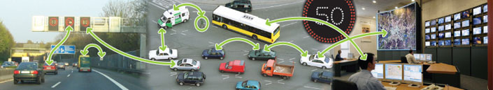
 HIGHWAY combines smart real-time maps, UMTS 3G mobile technology, positioning systems and intelligent agent technology, 2D/3D spatial tools and speech synthesis/voice recognition interfaces, to supply up-to-the-minute traffic or weather information information to drivers' mobile phones. HIGHWAY combines smart real-time maps, UMTS 3G mobile technology, positioning systems and intelligent agent technology, 2D/3D spatial tools and speech synthesis/voice recognition interfaces, to supply up-to-the-minute traffic or weather information information to drivers' mobile phones.
Before setting off on a journey, the driver will send the coordinates of his or her location and destination via the Global Positioning System (GPS). The service then fetches an up-to-date map of the route with driving conditions, speed limit data, accidents, traffic jams and road works information superimposed. The driver can also receive suggestions of alternative, safer courses to follow.
In addition to decreasing the probability for accidents and minimising potential damage to drivers and property, HIGHWAY services will be more cost-effective, efficient (saving time to customers) and informative (better informed travellers). The prototype of the traffic information service developed by the project has been successfully tested on the motorway linking the Finnish cities of Turku and Helsinki. Started in April 2004, this project is now completed
To learn more about this project, click here
Go back
|